Assessing approaching weather and changes in weather is difficult, even with sophisticated equipment. In the survival situation, the only course of action is to observe the weather and try to prepare for it, both mentally and physically.
Approaching weather cannot be altered, and unless your survival craft has sailing capabilities, it will be virtually impossible to avoid any oncoming weather. No matter what actions you take the weather will run its course. Correctly reading the approach of a storm, for instance, is of obvious value. It is more advantageous to the survivor afloat to be able to determine if clouds will yield rain.
Without having a radio with receiving capabilities, the only immediate criteria available to determine weather information is the following:
• Cloud patterns and formations
• Wind direction and intensity
• Swell size and direction
• Temperature changes
Studying cloud patterns and development is probably the best and easiest method available to the novice. Clouds are a visible sign of moisture in the air and their formation provides important clues to weather conditions.
Large masses of air in the earth’s mid-latitudes generally move in a west to east direction. Therefore, look to the west for signs of approaching weather and clouds that herald change. During the winter these air masses can attain speeds of 30 miles per hour covering about 700 miles a day. During summertime speeds can reach about 20 miles per hour, reaching 500 miles per day.
The following photos represent an example of the basic cloud genera and the typical conditions that result from them. Exceptions will always prevail but evidence shows that a high degree of consistency is present.
CLOUDS
High Clouds
Predominantly composed of ice crystals Cirrus (curl) (Fig. 4-1):

Fig. 4-1 Cirrus Cloud Formations.
• Generally white in color
• Delicate in appearance
• Composed of ice crystals
• Appear as:
1. Dense patches with frayed borders
2. Rounded tufts or hooks
3. Long thin lines reaching across the sky
4. Plume-like and feathery at times
• Generally related to fair weather, but could be the fore runner of rain if they are followed by lower and thicker clouds.

Cirrocumulus (Mackerel sky) (Fig. 4-2):
• Comprised of scales or white flakes, or globular masses
• Honeycomb appearance
• Resemble ripples in sand
• Commonly known as “mackerel sky” due to patterns resembling the scales on the back of a mackerel
• Layers show very slight vertical development
• Generally associated with fair weather, but if they thicken and lower wind and rain may follow

Fig. 4-2 Cirrocumulus Cloud Formations.
Cirrostratus: (Fig. 4-3):
• Contains an abundance of ice crystals
• Light refraction produces luminous tangent arc or “halo” effect in the sky
• Thin whitish transparent veil or web completely covering the sky
• Commonly known “mares’ tails” result from cirrus thickening and becoming cirrostratus.
• if thickening continues the ice crystals will melt to form water droplets, known as altostratus, and you may expect rain within 24 hours

Fig. 4-3 Cirrostratus Cloud Formation.
Middle Clouds
Altocumulus (Fig. 4-4):
• Composed of water droplets with ice crystals forming only at very low temperatures
• Usually seen as a sheet of regularly arranged cloudlets
• Known as “sheep backs” or “castles in the air”
• White and gray and appear rounded
• Often mistaken for stratocumulus
• Masses tend to merge together
• Occasionally appear shortly before a thunderstorm
• Usually indicate a change to unstable and thundery skies

Fig. 4-4 Altocumulus Cloud Formation.
Altostratus (Fig. 4-5):
• Composed of water droplets, raindrops, snowflakes, and ice crystals
• Bluish or grayish cloud sheet, veil or layer in fibrous or uniform appearance
• The sun or moon appears as though shining through “ground glass”
• Halos are not present
• Continuous rain or snow may be expected within a few hours if these clouds thicken and lower, or if rain clouds (nimbostratus) form below them appearing as a sort of “ragged scud”
Low Clouds
Stratocumulus (Fig. 4-6):
• Composed of water drops except in extreme cold weather
• Gray and whitish cloud layers with dark patches
• Soft in appearance
• Their motion is similar to ocean waves
• Vary greatly in altitude
• Usually clear skies will follow during the night

Fig. 4-6 Stratocumulus Cloud Formation.
Stratus (Fig. 4-7):
• Gray cloud layer with uniform base
• Resembles fog
• Produces drizzle or mist
• Stratus family clouds have a base that is below 1000 feet and becomes “fog” when on the ground
Fig. 4-7 Stratus Cloud Formation.
Nimbostratus (Fig. 4-8):
• Dark, gray cloud layer, thick enough to blot out the sun
• Continuous precipitation
• No electric or thunderous activity
• Shapeless cloud layer
• Typical rain cloud
Fig. 4-8 Nimbostratus Cloud Formation.
Vertical Clouds
Cumulus (Fig. 4-9):
• Generally dense and detached
• Developing as rising mounds or towers
• Brilliant white on top with a horizontal and somewhat dark base
• Dome shaped upper surface
• Commonly known as “woolpack” clouds
• Usually accompany fair weather
Fig. 4-9 Cumulus Cloud Formation.
Cumulonimbus (Fig. 4-10):
• Massive cloud pattern with anvil shape at top
• Reaches great heights
• Upper portion is formed of ice crystals
• Base is dark, horizontal, and becomes lower and ragged as showers occur
• Commonly known as thundercloud or thunderhead
Fig. 4-10 Cumulonimbus Cloud Formations.
RAIN CLOUDS
Your ability to recognize rain clouds is valuable because it is extremely important to take advantage of any conditions that will provide you with water. Water stores should be updated and topped off with fresh water whenever possible. If you are convinced that an approaching cloud will rain on you, it may be wise to issue extra water rations to the crew and drink some of the water in your stores in order to provide greater space for any fresh water you catch.
Proper recognition of a rain cloud will also allow you extra time to prepare for a new rainfall, and thus avoid having to waste time rigging a catchment during the rainfall.
LIGHTNING
When lightning is sighted in the distance there is a delay before hearing the thunder. The approximate distance of the lightning and storm in relation to where you are can be calculated by the following simple formula:
From the moment you see the lightning, count the seconds until you hear the thunder. To ascertain the distance in statute miles, divide the number of seconds by 5; it takes roughly that long for sound to travel over one mile. For the same distance in nautical miles divide the number by 5.5.
FOG
Fog is basically a cloud with its base on or near the surface of the ocean. Its occurrence is relatively rare at the equator or in the trade wind belt (with the exception of the coasts of California, Chili, Northwest and Southwest Africa).
Fog can have definite effects on your judgment in terms of distance and sound. If you are approaching a shore and are unable to see it because of a heavy fog layer, listen sharply for the break of waves on the shore. Re member that the sound you hear may be distorted from the layer of fog.
GENERAL CIRCULATION OF EARTH’S ATMOSPHERE
Briefly simplified, the general circulation of the earth’s atmosphere results from the sun’s effect on the earth’s surface, and the atmospheric temperatures. A low pres sure belt occurs near the equatorial latitudes. This belt, called the doldrums, is approximately midway between two high pressure belts. The surface airs of the earth tend to move from an area of high pressure to that of an area of low pressure (Fig. 4-11).
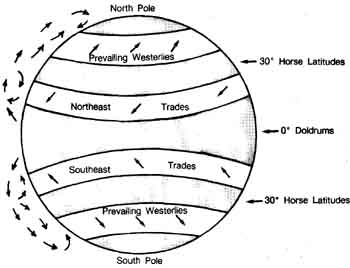
Fig. 4-11 General circulation of the earth’s atmosphere.
Doldrums
Doldrums is the belt of low pressure near the equator. The area is located between the north and south trade winds. This area experiences frequent showers and thundershowers and is often overcast. There may be prolonged periods of time without wind. Light winds that do blow are often inconsistent and vary in direction. Hot and sultry days are a common occurrence. Except for slight changes, the atmospheric pressure along the equatorial trough is almost uniform.
Trade Wind Belt
The trade winds are considered the most constant of winds. They are not necessarily continuous but are markedly more consistent with regard to season. In all areas they are “fresher” during the winter months than during the summer.
Trades blow from belts of high pressure to the equatorial belts of lower pressure. Trade winds in the northern hemisphere will come from the northeast, called the northeast trades. Trade winds in the southern hemisphere will come from the southeast, and are called the southeast trades.
Horse Latitudes
On the pole-ward side of each trade wind belt, and corresponding roughly with the zone of high pressure in each hemisphere, is an area with weak pressure gradients and variable winds. This region is called the horse latitudes. Unlike the weather in the doldrums, the weather in the horse latitudes is fresh and usually clear.
Westerlies
In the northern summer, the westerly wind belts are 35 degrees to about 65 degrees north, in the southern hemisphere summer 36 degrees to 65 degrees south. They are stronger in their perspective winters and stronger in the southern band. Their actual wind direction is variable from north-west to south-west. The variations in wind is due to a series of depressions passing through the area. Because there is less land interference in the southern hemisphere, the southern westerlies are stronger and are often referred to as the roaring forties.
Polar Winds
Temperatures near the geographic poles are low, and because of this, pressure tends to remain higher at the poles than in the surrounding regions. The polar winds blow outward from the poles and are deflected west by the earth’s rotation. They become known as the northeaster- lies in the Arctic and the south-easterlies in the Antarctic.
General Rule: Buys Ballot’s Law
If an observer in the northern hemisphere faces the wind, the center of low pressure is toward his right, and somewhat behind him; the center of high pressure is toward his left and somewhat in front of him.
If an observer in the southern hemisphere faces the wind, the center of low pressure is toward his left and somewhat behind him; and the center of high pressure is toward his right and somewhat in front of him.
Fronts
On weather maps, the boundary zones of different air masses are drawn in as lines, which are called weather fronts, or simply fronts. A front may be regarded as a line dividing two different air masses. The boundaries between air masses are really zones of transition, ranging from 5 to 60 miles in width. Weather fronts have been classified into a simple system for study:
• Cold Front— a front along which colder air replaces warmer air
• Warm Front —a front along which warmer air replaces colder air
• Occluded Front — a front resulting when a cold front over takes a warm front and the warm air is forced aloft
• Stationary Front — a front along which one air mass does not replace another air mass
Squall Lines
Squall lines, sometimes called instability lines, are extremely dangerous phenomena for small boats, and should be avoided, if at all possible. Squall lines are narrow zones of instability that sometimes occur 50 to 300 miles ahead of a fast-moving cold front. The development of squall lines takes place when winds above a cold frontal surface are moving in the same direction as the cold front, but at greater speed, and prevent the warm air ahead of the cold front from rising. Violent weather, extreme gustiness, and downpours often occur just behind the squall line.
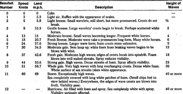
Beaufort Wind Scale
The Beaufort wind scale has been in general use for more than a hundred years. Most yachtsmen stick to the Beaufort scale for quoting wind strength because it was designed for sailing ships (Table 4-1).
PREV: How to Use Distress Signals, more
NEXT: Exposure: Hypothermia and Dehydration
All Sea Survival articles
© CRSociety.net